


As we drove from Las Vegas just past the limit of Death Valley National Park, we pulled over for the obligatory photo opportunity at the Death Valley National Park sign. At the bottom of the sign is a subheading: “Homeland of the Timbisha Shoshone,” a long-overdue recognition which was added shortly after the signing of the Timbisha Shoshone Homeland Act in 2000.

Life in this hot and arid region is not easy, but the Timbisha have called this area home for over a thousand years, and it certainly is incongruous to recognize the place in which you’ve lived as a valley of death.
In fact, it’s quite the opposite. The Shoshone have called this place Tümpisa (timbisha), which refers to the red ochre earth sourced from the Black Hills – medicinal material smudged onto faces for its healing properties. For the Timbisha, this is the Valley of the Red Ochre.
“The spirit of Timbisha has received many travelers from other lands, and all of Mother Earth’s belongings; the home of the Timbisha Shoshone Newe (Peoples), has been used as a commodity of sorts. Timbisha is not a “valley of death” – it is a valley of the Red Ochre. Red Ochre is used spiritually by the Newe with its “Healing Power.” Not of death but for life. Waters from the mountains to the east and west flow underground into this valley. Overflows of nearby springs once formed streams of surface water by its own course, bringing life.” – Pauline Esteves, Tribal Elder
The red coloring of the soil comes from deposits of iron oxide, which are prevalent throughout the area – one of the many characteristics that make this space so beautiful.


Artist’s Palette
Although Death Valley is the driest place in North America, it rained for two of the four days we were there. Never one to let a good crisis go to waste, I headed over to Artists Palette. Already a colorful site from the variety of mineral deposits – hematite pinks, reds and yellows; chlorite greens; and manganese purples – the relatively rare rain created even more saturated colors than usual. I also visited Artist’s Palette at sunset, and we had a colorful sky to complement the colorful hills.


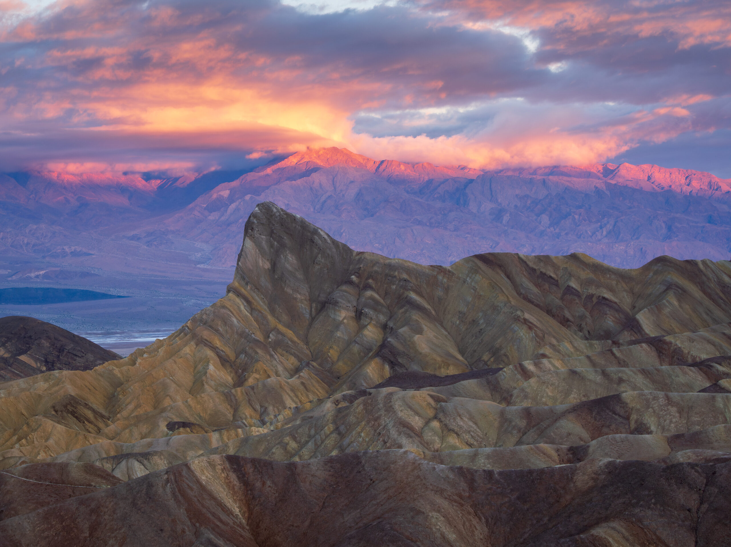
Zabriskie Point
Twice I went to Zabriskie Point to catch the sunrise. The first time, it rained hard, and the sunrise was a completely bust. But I returned the next day and the clouds to the west created a beautiful blue, lavender, and pink backdrop for the purple Panamint Mountains in the distance and the prominent Manly Beacon and the surrounding yellow and brown striped badlands hills below. Two hikers on the hills in the foreground provide much-welcome scale.


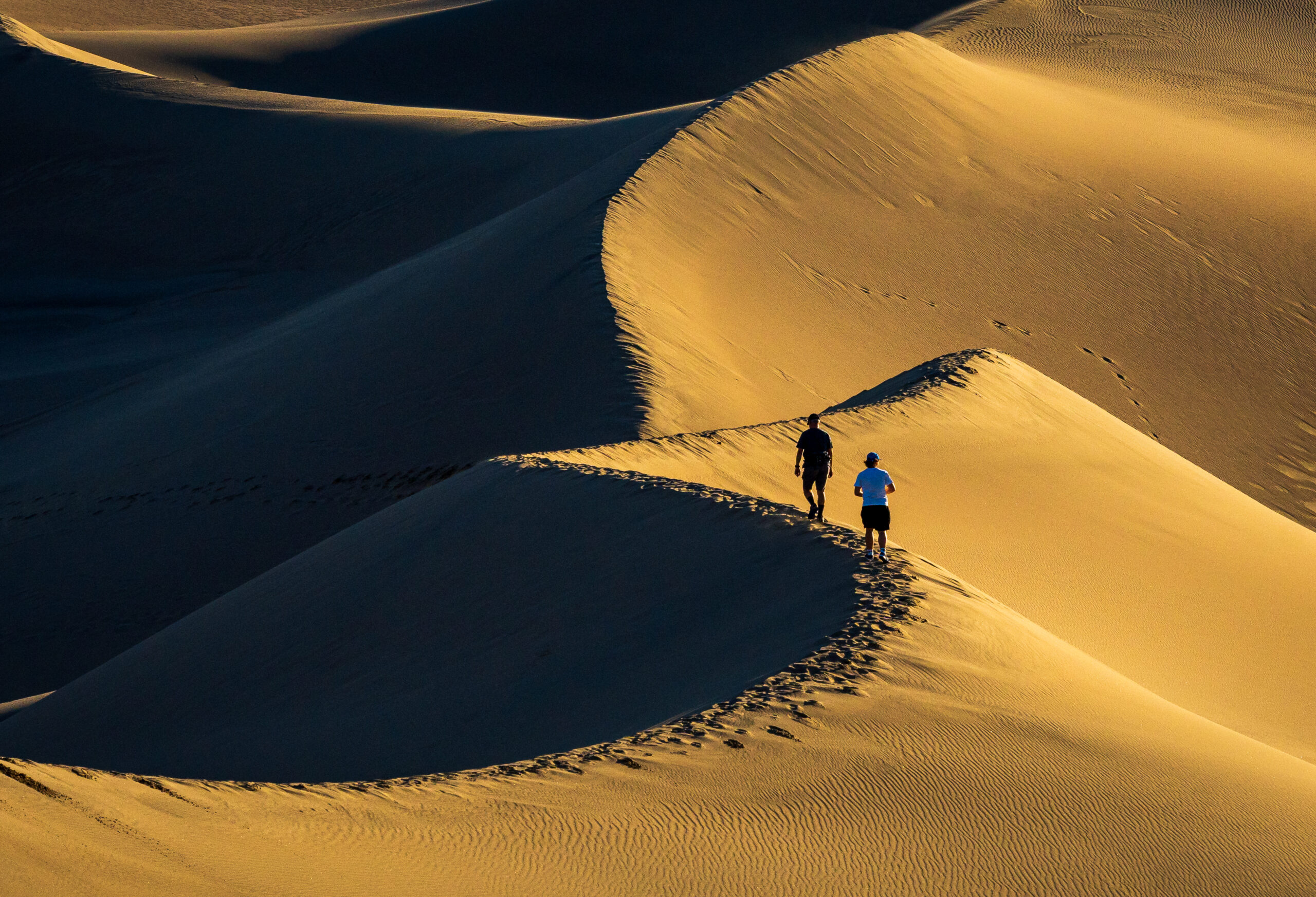
Mesquite Flat Sand Dunes
The colors and contrasts at sunset were a real delight. And after sunset, the clouds and mountains to the east created a beautiful violet complement to the soft tan dunes.


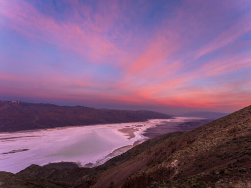
Dante’s View
At an elevation of 5,575 ft on the ridge of the Black Mountains with a view towering over Badwater Basin, Dante’s View is a great spot to watch the sun set, and I was treated to crepuscular rays (“god rays”) as the sun burst through the clouds.
Normally providing a view of the salt flats below, when I visited, the area was largely filled with the shallow, temporary – and rare – “Lake Manly.”


Lake Manly
Informally called “Lake Manly,” the lake in Badwater Basin formed following record rains in the summer of 2023. The lake has been slowly evaporating, but it has also been recharged by additional rain events, including one during our visit.


Striped Butte
On two separate days, we rented Jeeps from Farabee’s so we could drive to more remote locations on backcountry roads that require high clearance vehicles with reliable tires.
One day, we drove through Warm Spring Canyon and Butte Valley. The highlight of Butte Valley is the stunning Striped Butte, composed of steeply tilted limestone beds of the Permian Anvil Spring Formation.

Geologists’ Cabin
Nearby to Striped Butte is the “Geologists’ Cabin” – one of the first-come, first-served backcountry cabins that are maintained by volunteers and visitors.


Petroglyphs
In the Warm Spring Canyon area, we also explored a mountainside that was covered in petroglyphs. I’m not going to share the exact location, but it took several hours of backcountry driving followed by hiking along burro trails to reach.

Ubehebe Crater
A half mile in diameter and nearly 800 feet deep, Ubehebe Crater was formed when molten lava came in contact with water, resulting in a powerful steam explosion. It’s relatively easy to visit, because miraculously it exploded within just a few feet of a small parking area (visible to the left on the photo below).


Joshua Trees
On the way to Racetrack Playa, you pass a forest of Joshua Trees. In fact, they’re not trees at all, but rather a type of yucca that can grow up to 30 feet tall.

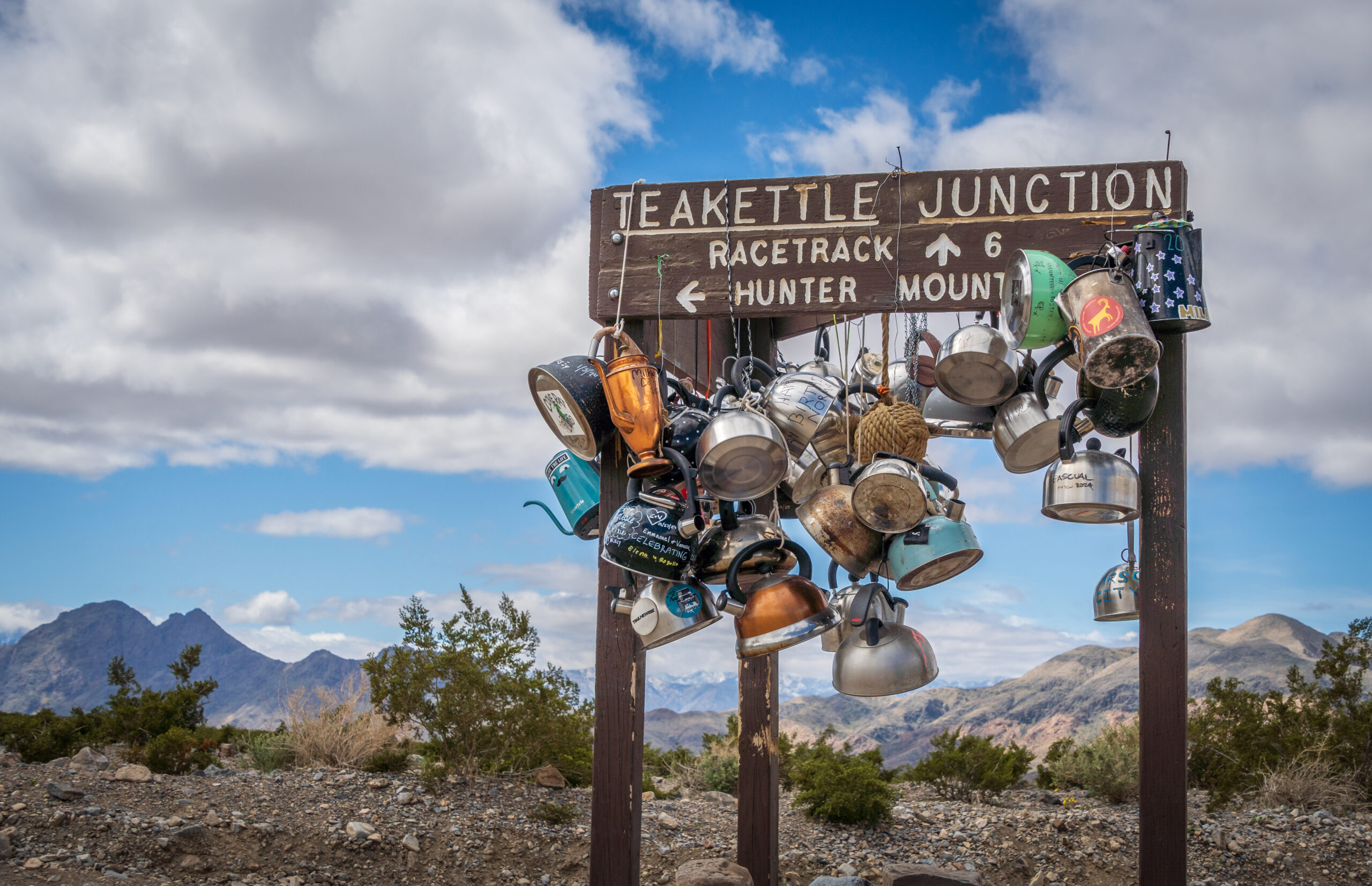
Teakettle Junction
After about 20 miles on Racetrack Road, you reach Teakettle Junction. At this junction of two roads, a sign is covered in decorated tea kettles that are left behind by visitors.
Racetrack Playa & Moving Rocks
Racetrack Playa is a dry lakebed which is one of the flattest natural surfaces on earth, with the north end of the playa only two inches higher in elevation than the south end. Rocks from the surrounding mountains fall onto the playa and move around, leaving mysterious tracks on the surface. The mystery was finally solved by researchers in 2013:
Their observations show that moving the rocks requires a rare combination of events. First, the playa fills with water, which must be deep enough to allow formation of floating ice during cold winter nights but shallow enough to expose the rocks. As nighttime temperatures plummet, the pond freezes to form sheets of “windowpane” ice, which must be thin enough to move freely but thick enough to maintain strength. On sunny days, the ice begins to melt and break up into large floating panels, which light winds drive across the playa pool. The ice sheets shove rocks in front of them and the moving stones leave trails in the soft mud bed below the pool surface.


Lost Burro Mine
Not far from The Racetrack, taking a turn east at Teakettle Junction, is the Lost Burro Mine. We explored the area, including a cabin which is still in relatively good shape.

Wildflowers
Around Ubehebe Crater, we were treated to fields full of bright yellow wildflowers.


Feral Burros
Death Valley has invasive burros (Equua asinus) which can be found in parts of the backcountry. The species were originally descended from the African wild ass and are not native to North America. We saw the burros in two different areas. They are very social animals.


I thought that four full days in Death Valley would be enough, but it felt like we barely scratched the surface. I look forward to coming back again some day.

Discover more from From My Perspective
Subscribe to get the latest posts sent to your email.